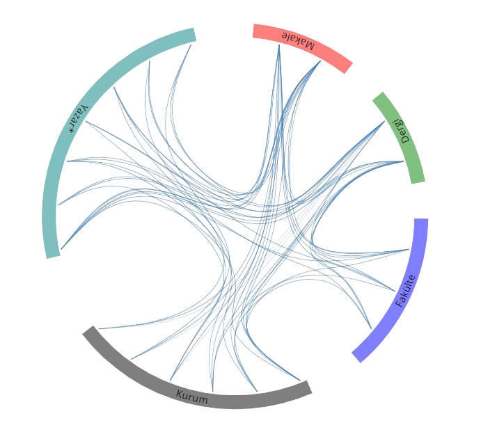
Yayınlar & Eserler

SCI, SSCI ve AHCI İndekslerine Giren Dergilerde Yayınlanan Makaleler

Diğer Dergilerde Yayınlanan Makaleler

Hakemli Kongre / Sempozyum Bildiri Kitaplarında Yer Alan Yayınlar

ACCESSIBILITY ANALYSIS OF STREET NETWORKS USING SPACE SYNTAX

7th International Conference on Cartography GIS, SOZOPOL, Bulgaristan, 18 - 23 Haziran 2018, cilt.1, ss.352-360 identifier

3D Shoreline Mapping with Unmanned Aerial Vehicle

Proc. on FIG Congress 2018, Embracing Our Smart World Where the Continents Connect: Enhancing the Geospatial Maturity of Societies, 6 - 11 Mayıs 2018

Navigation System for Blind, Hearing and Visually Impaired People in ITU Ayazaga Campus

International Conference on Computing Networking and Informatics (ICCNI), Ota, Japonya, 29 - 31 Ekim 2017 Sürdürülebilir Kalkınma identifier

Sediment Monitoring In Dams with Bathymetric Survey for the Management of Natural Water Resources: Obruk Lake Dam Case

The 19th International Symposium on Environmental Pollution and its Impact on Life in the Mediterranean Region-MESAEP 2017, 4 - 06 Ekim 2017

Analyzing Impact Area of OSYM Offices in Istanbul by IDW Method

American Geophysical Union 2016, San-Francisco, Kostarika, 12 - 16 Aralık 2016

Analyzing Spatial Distribution of OSYM Offices in Istanbul Due to the Service Areas

International Scientific Conference on Applied Sciences ISCAS 2016, Antalya, Turkiye, Antalya, Türkiye, 27 - 30 Eylül 2016

Deformation Monitoring Studies and GPR Measurements on Dams

American Geophysical Union 2015, San-Francisco, Kostarika, 14 - 18 Aralık 2015

A New Approach for Quantitative Measure of Urban Complexity by Metric Entropy Method

Mediterranean Scientific Association of Environmental Protection, Creteil, Fransa, 26 - 30 Eylül 2015

Deformation Monitoring and Bathymetry Analyses in Rock Fill Dams a Case Study at Ataturk Dam

American Geophysical Union 2014, San-Francisco, Kostarika, 15 - 19 Aralık 2014

Dam Safety and Deformation Monitoring in Dams

American Geophysical Union 2013, San-Francisco, Kostarika, 9 - 13 Aralık 2013

Evaluation of Spatial Information on Maps

15th International Convention and Fair Informatica 2013, Havana, Küba, 18 - 22 Mart 2013

Deformasyon İzleme Teknikleri Atatürk Barajı Örneği

6. Mühendislik Ölçmeleri Sempozyumu, Afyon Kocatepe Üniversitesi, Türkiye, 3 - 05 Ekim 2012

Latest Results of Landslide Deformation Project in Harbor of Ambarlı Region

FIG Working Week, Marrakech-Morocco, MOROCCO, 18 - 22 Mayıs 2011

Deformation Monitoring Studies at Atatürk Dam

XXIV. FIG International Congress 2010, Sydney, Avustralya, 11 - 16 Nisan 2010

Ambarlı Liman Bölgesinde Heyelan İzleme Çalışmalarında Son Durum

4. Ulusal Mühendislik Ölçmeleri Sempozyumu, Trabzon, Türkiye, 14 - 16 Ekim 2009, ss.353-364

Entropy Analysis of Images Used In Disaster Information Systems

TIEMS 16th Annual Conference, İstanbul, 9 - 11 Haziran 2009

Deformation Monitoring of Atatürk Dam

TIEMS 2009 Annual Conference, İstanbul, Türkiye, 9 - 11 Haziran 2009, ss.300-310

Dağcılık Faaliyetlerine Yönelik Coğrafi Bilgi Sistemi Oluşturulması ve Tematik Harita Üretimi

TMMOB Harita ve Kadastro Mühendisleri Odası Ulusal Coğrafi Bilgi Sistemleri Kongresi, Türkiye, 30 Ekim - 02 Kasım 2007, cilt.2, ss.742-747 Sürdürülebilir Kalkınma

An Entropic Evaluation of Topographic Data Used in Disaster Information Systems

International Symposium on Earthquake Loss Estimation for Turkey, Istanbul, İstanbul, Türkiye, 24 - 26 Eylül 2007

Geodetic Monitoring in The Biggest Dam Of Turkey Ataturk Dam

Modern Technologies, Education And Professional Practice In Geodesy And Related Fields, 9 - 10 Kasım 2006

Creating Basic Spatial-Topographic Object Model for ITU-ACDIS

International Conference on Cartography and GIS, BOROVETS, Bulgaristan, 25 - 28 Ocak 2006

Disaster Information System of TURKEY TABIS GIS Standards

1st International Workshop on An Earthquake Loss Estimation Program for Turkey, 1 - 02 Aralık 2005

Forming The Geodetic Infrastructure of Engineering Projects by GPS and Different Levelling Methods

International Symposium on Modern Technologies, Education And Professional Practice In Geodesy And Related Fields, Sofija, Bulgaristan, 3 - 04 Kasım 2005, ss.169-178

Küresel Rotaların Uygun Kartografik Gösterimi

TMMOB Harita ve Kadastro Müh. Odası 10.Sürekli ve Bilimsel Tek. Kurult, ODTÜ, Ankara, Ankara, Türkiye, 28 Mart - 01 Nisan 2005

CBS Etiği

TMMOB Harita ve Kadastro Müh. Odası 10.Sürekli ve Bilimsel Tek. Kurult, Ankara, Türkiye, 28 Mart - 01 Nisan 2005

GPS measurements along the North Anatolian Fault zone on the mid-Anatolia segment

IAG Symposium on Geodetic Deformation Monitoring - From Geophysical to Engineering Roles, Jaen, İspanya, 17 - 19 Mart 2005, cilt.131, ss.166-171 identifier identifier

GIS Standards of Turkey based on Emergency Management

International Symposium on GIS, İstanbul, Türkiye, 23 - 26 Eylül 2002

Metrikler

Yayın

73

Atıf (WoS)

30

H-İndeks (WoS)

4

Atıf (Scopus)

43

H-İndeks (Scopus)

4

Proje

4

Açık Erişim

2
BM Sürdürülebilir Kalkınma Amaçları