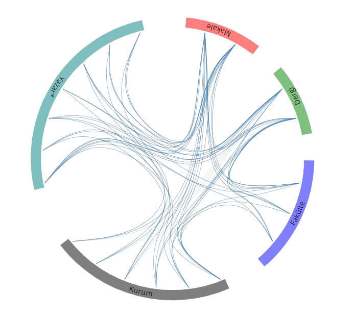
Yayınlar & Eserler

SCI, SSCI ve AHCI İndekslerine Giren Dergilerde Yayınlanan Makaleler

Diğer Dergilerde Yayınlanan Makaleler

Hakemli Kongre / Sempozyum Bildiri Kitaplarında Yer Alan Yayınlar

Sentinel-1 and -2 time-series data-fusion for olive tree identification in heterogeneous land surfaces using Google Earth Engine

2nd Intercontinental Geoinformation Days (IGD) – 5-6 May 2021, Mersin, Türkiye, 06 Mayıs 2021, cilt.1, ss.159-162 Sürdürülebilir Kalkınma

IMPROVED URBAN LAND COVER/USE MAPPING USING SENTINEL-2A IMAGERY

International Symposium on Applied Geoinformatics (ISAG-2019), İstanbul, Türkiye, 7 - 09 Kasım 2019, cilt.1, ss.296-301

Evaluation Of Satellite AOD Observations for Monitoring Air Quality

International Symposium on Applied Geoinformatics, 7 - 09 Kasım 2019

SEPARATING OLIVE TREES FROM AGRICULTURAL AREAS AND BARE LANDS BY USING SPECTRAL INDICES WITH MULTI-TEMPORAL SENTINEL-2 IMAGES

International Symposium on Applied Geoinformatics (ISAG-2019), İstanbul, Türkiye, 7 - 09 Kasım 2019, cilt.1, ss.415-420

COMPARATIVE ANALYSIS OF DIGITAL SURFACE MODEL EXTRACTION APPROACHES FOR TRI-STEREO SATELLITE IMAGES

International Symposium on Applied Geoinformatics (ISAG-2019), İstanbul, Türkiye, 7 - 09 Kasım 2019, cilt.1, ss.35-39

INVESTIGATION AND MAPPING THE RELATIONSHIP BETWEEN 4G SIGNAL STRENGTH AND TOPOGRAPHY FOR DIFFERENT OPERATORS

The 40th Asian Conference on Remote Sensing (ACRS 2019), Daejeon, Güney Kore, 14 - 18 Ekim 2019

Determination of the flooded agricultural lands with spot 6 high resolution satellite images: A case study of menderes plain, turkey

8th International Conference on Agro-Geoinformatics, Agro-Geoinformatics 2019, İstanbul, Türkiye, 16 - 19 Temmuz 2019 identifier

Determination of olive trees with multi-sensor data fusion

8th International Conference on Agro-Geoinformatics, Agro-Geoinformatics 2019, İstanbul, Türkiye, 16 - 19 Temmuz 2019 identifier

CORRECTION OF TOPOLOGICAL ERRORS OF UTILITY NETWORK SYSTEM

The 39th Asian Conference on Remote Sensing, 15 - 19 Ekim 2018

Development of 4th Level CORINE Land Cover/Land Use Nomenclature for Turkey

38th Annual EARSeL Symposium 3rd Joint EARSeL LULC and NASA LCLUC Workshop, 9 - 12 Temmuz 2018 Sürdürülebilir Kalkınma

Impacts of Forest Cover Changes on Land Surface Temperatures: A Remote Sensing Study of Istanbul Northern Forests

intenational conference on agriculture, forest, food sciences and technologies, ÇEŞME, Türkiye, 2 - 05 Nisan 2018, ss.716-723 Sürdürülebilir Kalkınma

Multi-temporal analysis of land surface temperature in highly urbanized districts

2017 AGU Fall Meeting, NEW ORLEANS, Amerika Birleşik Devletleri, 11 - 15 Aralık 2017

Determining Linear and Areal Morphological Characteristics of Melen Watershed in Turkey

IWA2nd Regional Symposium on Water,Wastewater and Environment, İzmir, Türkiye, 22 - 24 Mart 2017, ss.34-44

Multi-Temporal Analysis of Urban Area Changes Using Built-Up Index

ACRS 2016, Colombo, Sri Lanka, 17 - 21 Ekim 2016, ss.1-6

3D Visualization with Lazer Scanning

Selçuk International Scientific Conference on Applied Sciences, Antalya, Türkiye, 27 - 30 Eylül 2016, ss.268-272

3D VISUALIZATION WITH LASER SCANNING

Selçuk International Scientific Conference on Applied Sciences, 27 - 30 Eylül 2016

Accuracy of 3D Terrain Models Used in Simulations

Selçuk International Scientific Conference on Applied Sciences, Antalya, Türkiye, 27 - 30 Eylül 2016, ss.244-248

ASSESSMENT OF FIRE SEVERITY AND POST-FIRE REGENERATION BASED ON TOPOGRAPHICAL FEATURES USING MULTITEMPORAL LANDSAT IMAGERY: A CASE STUDY in MERSIN, TURKEY

23rd Congress of the International-Society-for-Photogrammetry-and-Remote-Sensing (ISPRS), Prague, Çek Cumhuriyeti, 12 - 19 Temmuz 2016, cilt.41, ss.763-769 Sürdürülebilir Kalkınma identifier identifier

Analysing The Effects Of Different Land Cover Types On Land Surface Temperature Using Satellite Data

Int. Arch. Photogramm. Remote Sens. Spatial Inf. Sci, Kish Island, İran, 23 - 25 Kasım 2015, ss.665-667

Comparison of pixel-based and object-oriented classification methods

36th Asian Conference on Remote Sensing: Fostering Resilient Growth in Asia, ACRS 2015, Quezon City, Metro Manila, Filipinler, 24 - 28 Ekim 2015 identifier

Satellite based multi temporal assessment of a dried lake case study of Akgol wetland

18th International Symposium on Environmental Pollution and its Impact on Life in the Mediterranean Region, Girit, Yunanistan, 26 - 30 Eylül 2015, ss.13 Sürdürülebilir Kalkınma

Geosynthetic Based Scour Protection Around The Slender Pile Under Waves

14th International Multidisciplinary Scientific Geoconference, SGEM 2014, GeoConference on Water Resources, Forest, Marine and Ocean Ecosystems, Albena, Bulgaristan, 17 - 26 Haziran 2015, ss.607-614

Nehir Havzalarının Morfolojik Karakteristiklerinin CBS Destekli Nümerik Modeller Kullanılarak Analizi

Türkiye Ulusal Fotogrametri ve Uzaktan Algılama Birliği VIII Sempozyumu, Konya, Türkiye, 21 - 23 Mayıs 2015, ss.177-182

Yerleşim Alanı Uygunluk Analizi: LUCIS Model

Türkiye Ulusal Fotogrametri ve Uzaktan Algılama Birliği VIII Sempozyumu, Konya, Türkiye, 21 - 23 Mayıs 2015, ss.146-149

Mekansal Otokorelasyon Teknikleri Kullanılarak MODIS Uydu Görüntüleri Üzerinden Yanmış Alan ve Yanma Şiddetinin Belirlenmesi

V. Uzaktan Algılama ve Coğrafi Bilgi Sistemleri Sempozyumu, UZALCBS, İstanbul, Türkiye, 14 - 17 Ekim 2014, ss.1-6

GIS Based Carbon Dioxide Concentration Research in ITU Campus

XXV FIG Congress, Kuala Lumpur, Malezya, 16 - 21 Haziran 2014, ss.1-6

Urbanization and Deforestration A Case Study from a Mega City Istanbul

Proceedings of the 34 th ACRS-Asian Conference on Remote Sensing, 20 - 24 Ekim 2013 Sürdürülebilir Kalkınma

Urbanisation and deforestration: A case study from a mega city - Istanbul

34th Asian Conference on Remote Sensing 2013, ACRS 2013, Bali, Endonezya, 20 - 24 Ekim 2013, cilt.2, ss.1815-1819 identifier

Determination of characteristic properties of rural residental areas using remotely sensed data

34th Asian Conference on Remote Sensing 2013, ACRS 2013, Bali, Endonezya, 20 - 24 Ekim 2013, cilt.1, ss.642-649 identifier

Unsupervised identification of vineyard parcels using SPOT5 images by utilizing spectral and textural features

The Second International Conference on Agro-Geoinformatics, Fairfax, Amerika Birleşik Devletleri, 12 - 16 Ağustos 2013, ss.61-65

Vineyards Mapping Using Object Based Analysis

2nd International Conference on Agro-Geoinformatics (Agro-Geoinformatics), Virginia, Amerika Birleşik Devletleri, 12 - 16 Ağustos 2013, ss.66-70 identifier identifier

Vineyards Mapping Using Object Based Image Analysis

The Second International Conference on Agro-Geoinformatics, Fairfax, Amerika Birleşik Devletleri, 12 - 16 Ağustos 2013, ss.66-70

Unsupervised Classification of Vineyard Parcels Using SPOT5 Images by Utilizing Spectral and Textural Features

2nd International Conference on Agro-Geoinformatics (Agro-Geoinformatics), Virginia, Amerika Birleşik Devletleri, 12 - 16 Ağustos 2013, ss.61-65 Sürdürülebilir Kalkınma identifier identifier

Research on Agricultural Mapping Capabilities of the SPOT 6 Satellite Images

The Second International Conference on Agro-Geoinformatics, Fairfax, Amerika Birleşik Devletleri, 12 - 16 Ağustos 2013, ss.93-96

A research on Agricultural Mapping Capabilities of the SPOT 6 Satellite Images

2nd International Conference on Agro-Geoinformatics (Agro-Geoinformatics), Virginia, Amerika Birleşik Devletleri, 12 - 16 Ağustos 2013, ss.93-96 identifier identifier

Uydu Görüntüsü Zenginleştirme Yöntemleri Kullanılarak Litolojik Birimlerin Ayırt Edilmesi

14. Türkiye Harita Bilimsel ve Teknik Kurultayı, Ankara, Türkiye, 14 - 17 Mayıs 2013, ss.1-6

Uzaktan Algılama Verileri Yardımıyla Yer Yüzey Sıcaklığının Belirlenmasi

14. Türkiye Harita Bilimsel ve Teknik Kurultayı, Ankara, Türkiye, 14 - 17 Mayıs 2013, ss.1-6

Spatio-temporal analysis of urbanization related land use/cover dynamics using satellite imagery: Case study antalya, Turkey

33rd Asian Conference on Remote Sensing 2012, ACRS 2012, Pattaya, Tayland, 26 - 30 Kasım 2012, cilt.2, ss.1111-1116 Sürdürülebilir Kalkınma identifier

Analysis of remotely sensed data by means of logic filters

33rd Asian Conference on Remote Sensing 2012, ACRS 2012, Pattaya, Tayland, 26 - 30 Kasım 2012, cilt.2, ss.959-966 identifier

DEM accuracy of high resolution satellite images

12th International Conference on Computational Science and Its Applications, ICCSA 2012, Salvador de Bahia, Brezilya, 18 - 21 Haziran 2012, ss.471-480 identifier identifier

Toprak Sınıfları İle Arazi Kullanımının Karşılaştırılması; Filyos Havzası Örneği

II. Ulusal Toprak ve Su Kaynakları Kongresi, Ankara, Türkiye, 22 - 25 Kasım 2011, ss.1-6

Kentsel Alanlarda Toprak Alanı Değişiminin V-I-S Bileşenleri İle Zamansal Analizi

II. Ulusal Toprak ve Su Kaynakları Kongresi, Ankara, Türkiye, 22 - 25 Kasım 2011, ss.1-6

Determining the Roughness Angles of Surfaces Using Laser Scanners

FIG Working Week “Bridging the Gap between Cultures, Marrekesh, Fas, 18 - 22 Mayıs 2011, ss.1-8

Lojik Filtrelerin Uzaktan Algılamada Kullanımı: V-I-S Model Üzerinde Bir Uygulama Örneği

13. Türkiye Harita Bilimsel ve Teknik Kurultayı, Ankara, Türkiye, 18 - 22 Nisan 2011, ss.1-6

Yüzeylerin pürüzlülük açılarının lazer tarayıcılar yardımıyla belirlenmesi

13. Türkiye Harita Bilimsel ve Teknik Kurultayı ölçme teknolojileri ve yazılım fuarı, Ankara, Türkiye, 1 - 03 Mart 2011

Temporal Impact of Urbanization on Forest in the Mega City Istanbul

1st International Turkey&Japan Environment and Forestry Symposium, Trabzon, Türkiye, 4 - 06 Kasım 2010, ss.224-237 Sürdürülebilir Kalkınma

Matlab&Simulink Kullanılarak Bitki Örtüsü, Su Geçirmezalan, Toprak Modelinin Otomasyonu

III. Uzaktan Algılama ve Coğrafi Bilgi Sistemleri Sempozyumu, UZALCBS, Kocaeli, Türkiye, 11 - 13 Ekim 2010, ss.428-435 Sürdürülebilir Kalkınma

Object identification using multi-resolution satellite sensor images

29th Asian Conference on Remote Sensing 2008, ACRS 2008, Colombo, Sri Lanka, 10 - 14 Kasım 2008, cilt.3, ss.1483-1489 identifier

Şehir Isı Adalarının Uzaktan Algılama Görüntü Verileri İle Belirlenmesi

Kent Yönetimi, İnsan ve Çevre Sorunları Sempozyumu, İstanbul, Türkiye, 2 - 06 Kasım 2008, ss.561-569

Yüksek Çözünürlüklü Uydu Görüntülerinden Kentsel Alanlardaki Değişimlerin 3 Boyutlu Analizi

Kent Yönetimi, İnsan ve Çevre Sorunları Sempozyumu, İstanbul, Türkiye, 2 - 06 Kasım 2008, ss.570-576

Evaluation of Urban Heat Island in Istanbul Using Remote Sensing Techniques

, XXIth Congress of The International Society for Photogrammetry and Remote Sensing (ISPRS), Pekin, Çin, 4 - 11 Temmuz 2008, ss.971-976

Spatial Prediction of Transport Related Urban Air Quality

XXIth Congress of The International Society for Photogrammetry and Remote Sensing (ISPRS), Pekin, Çin, 4 - 11 Temmuz 2008, ss.805-809

Analysis of meandering effects using digital elevation model integrated with remotely sensed data

28th Asian Conference on Remote Sensing 2007, ACRS 2007, Kuala-Lumpur, Malezya, 12 - 16 Kasım 2007, cilt.1, ss.219-225 identifier

Açık Maden Ocaklarının Kıyı Erozyonuna Etkisinin Zamansal Analizi

III. Ulusal Su Mühendisliği Sempozyumu, İzmir, Türkiye, 10 - 14 Eylül 2007, ss.465-471

Predictive Mapping of Air Pollutants A Spatial Approach

5th International symposium on Spatial Data Quality SDQ 2007, Modelling qualities in space and time, Enschede, Hollanda, 13 - 15 Haziran 2007, cilt.2, ss.1-5

Predictive Mapping of Air Pollutants: A GIS Framework

5th International Symposium on Spatial Data Quality, Enschede, Hollanda, 13 - 15 Haziran 2007, ss.1-6

Mekansal Analiz İçin Jeo-İstatistik Yaklaşım

TUFUAB IV Sempozyumu, İstanbul, Türkiye, 5 - 07 Haziran 2007, ss.1-6

Almus Fay Zonu’nun Uzaktan Algılama ve Sayısal Arazi Modeli Teknikleri ile Araştırılması

11. Türkiye Harita Bilimsel ve Teknik Kurultayı, Ankara, Türkiye, 2 - 06 Nisan 2007, ss.1-6

Uzaktan Algılanmış Verilerin Semivariogram Modeli

1. Uzaktan Algılama ve CBS Çalıştay ve Paneli, İstanbul, Türkiye, 27 - 29 Kasım 2006, ss.1-6

Havza Karakteristiklerinin Uzaktan Algılama ve Sayısal Arazi Modeli ile Analizi: Filyos Havzası

Türkiye’nin Kıyı ve Deniz Alanları VI. Ulusal Konferansı, Muğla, Türkiye, 7 - 11 Kasım 2006, ss.839-847

Assesment of forest degradation by means of remotely sensed data

25th Symposium of the European-Association-of-Remote-Sensing-Laboratories (EARSeL), Oporto, Portekiz, 6 - 11 Haziran 2005, ss.413-415 Sürdürülebilir Kalkınma identifier

Disaster Information System of TURKEY TABIS GIS Standards

1st International Workshop on An Earthquake Loss Estimation Program for Turkey, 1 - 02 Aralık 2005

Depremin Neden Olduğu Ağır Hasarların Uydu Görüntü Verileri Semivariogram İle Analizi

Bilimde Modern Yöntemler Sempozyumu, Kocaeli, Türkiye, 16 - 18 Kasım 2005, ss.721-729

Uydu Görüntülerinde Geometrik Düzeltme İşlemleri İçin Kullanılan Modellerin Sorgulanması

Bilimde Modern Yöntemler Sempozyumu, Kocaeli, Türkiye, 16 - 18 Kasım 2005, ss.651-659

Akarsulardaki Menderesleşmenin Uydu Görüntüleri Yardımıyla Analizi

2. Ulusal Su Mühendisliği Sempozyumu, İzmir, Türkiye, 21 - 24 Eylül 2005, ss.505-515

Analyses of Earthquake Induced Damage in Urban Areas by Means of Remotely Sensed Data

25th EARSeL Symposium. Global Developments in Environmental Earth Observation from Space, Porto, Portekiz, 6 - 11 Haziran 2005, ss.1-6

Analysis of geometric accuracy of Landsat 5 TM and IRS 1D data by means of DGPS and Map data

25th EARSeL Symposium. Global Developments in Environmental Earth Observation from Space, Porto, Portekiz, 6 - 11 Haziran 2005, ss.1-6

Depremin Neden Olduğu Ağır Hasarın Şehir Alanına Etkisinin Uzaktan Algılama Verileri ile Belirlenmesi

10. Türkiye Harita Bilimsel ve Teknik Kurultayı, Ankara, Türkiye, 28 Mart - 01 Nisan 2005, ss.127-136

Farklı Çözünürlükteki Uydu Görüntülerinin Geometrik Dönüşümü

10. Türkiye Harita Bilimsel ve Teknik Kurultayı, Ankara, Türkiye, 28 Mart - 01 Nisan 2005, ss.882-894

İstanbul Anadolu Yakası 2B Alanlarının Uydu Görüntüleri ile Analizi

10. Türkiye Harita Bilimsel ve Teknik Kurultayı, Ankara, Türkiye, 28 Mart - 01 Nisan 2005, ss.89-100

Use of Corona, Landsat TM, Spot 5 images to assess 40 years of land use/cover changes in Cavusbasi

24th Symposium of the European-Association-of-Remote-Sensing-Laboratories (EARSeL), Dubrovnik, Hırvatistan, 25 - 27 Mayıs 2004, ss.161-165 Sürdürülebilir Kalkınma identifier

Analyses of Izmit Earthquake by Means of Remotely Sensed Data: A Case Study, Yalova City

Proceeding of the 5th European Conference on Product and Process Modelling in the Building and Construction Industry, ECPPM 2004, eWork and eBusiness in Architecture, Engineering and Construction, İstanbul, Türkiye, 8 - 10 Eylül 2004, ss.603-608

Displaying Earthquake damage an Urban Area Using a Vegetation-Impervious-Soil Model and Remotely Sensed Data

XXth Congress of the International Society for Photogrammetry and Remote Sensing (ISPRS), İstanbul, Türkiye, 12 - 25 Temmuz 2004, ss.631-638

Environmental change detection using satellite data: Mapping northwest side of Istanbul

24th Symposium of the European-Association-of-Remote-Sensing-Laboratories (EARSeL), Dubrovnik, Hırvatistan, 25 - 27 Mayıs 2004, ss.175-181 Sürdürülebilir Kalkınma identifier

Environmental Change Detection Using Satellite Data

24th EARSeL Symposium New Strategies for Europe, Remote Sensing, Dubrovnik, Hırvatistan, 25 - 27 Mayıs 2004, ss.175-181 Sürdürülebilir Kalkınma

Use of Corona, Landsat TM Images to Asses 40 years of Landuse/cover changes in Cavusbasi

24th EARSeL Symposium New Strategies for European Remote Sensing, Dubrovnik, Hindistan, 25 - 27 Mayıs 2004, ss.161-165

Remote Sensing Aided Quantitative Analysis of Freshwater Flume of Filyos River in the Black Sea

36th Scientific Meeting of the Estuarine and Costal Sciences Association (ECSA), Dublin, İrlanda, 17 - 22 Ağustos 2003

Monitoring a Coastal Zone for Conflict Management

10 International Conference GIS, Ostrava, Çek Cumhuriyeti, 26 - 29 Ocak 2003, ss.1-6

Analyzing features obtained from satellite data by means of GIS

22nd Symposium of the European-Association-of-Remote-Sensing-Laboratories, PRAGUE, Çek Cumhuriyeti, 4 - 06 Haziran 2002, ss.653-657 Sürdürülebilir Kalkınma identifier

Kentsel Değişimlerin Uydu Görüntüleri ile Analizi

, Selçuk Üniversitesi, Jeodezi ve Fotogrametri Müh. Öğretiminde 30. Yıl Sempozyumu, Konya, Türkiye, 16 - 18 Ekim 2002, ss.416-424

Uydu Görüntülerinin Çözünürlüğe Bağlı Geometrik Doğruluğunun GPS ve Harita Koordinatları Kullanılarak An

Selçuk Üniversitesi, Jeodezi ve Fotogrametri Müh. Öğretiminde 30. Yıl Sempozyumu, Konya, Türkiye, 16 - 18 Ekim 2002, ss.443-450

Uydu Görüntüleri ve Coğrafi Bilgi Sistemlerinin Orman Haritalarnın Oluşturulmasında Kullanımı

Türkiye Ulusal Orman Envanteri Uluslararası Sempozyumu, İstanbul, Türkiye, 24 - 28 Eylül 2002, ss.1-5 Sürdürülebilir Kalkınma

GIS Standards of Turkey based on Emergency Management

International Symposium on GIS, İstanbul, Türkiye, 23 - 26 Eylül 2002

Environmental Effects Aassessment of Landfill Sites by Means of Remote Sensing Imagery and GIS

ISWA World Environmental Congress and Exhibition, Appropriate Environmental and Solid Waste Management and Technologies for Developing Countries, İstanbul, Türkiye, 8 - 12 Temmuz 2002, ss.2461-2468

Analysing Features Obtained from Satellite Data by Means of GIS

22. EARSeL Symposium, Geoinformation for European –Wide Integration, Prag, Çek Cumhuriyeti, 4 - 06 Haziran 2002, ss.653-657

Geometric Correction of Satellite Images Using DGPS

22. EARSeL Symposium, Geoinformation for European-Wide Integration, Prag, Çek Cumhuriyeti, 4 - 06 Haziran 2002, ss.177-182

A Case Study of Using Remote Sensing Data and GIS for Land Management; Catalca Region

XXII FIG International Congress, Washinton, Amerika Birleşik Devletleri, 19 - 26 Nisan 2002

Using satellite data for land use change detection: a case study for Terkos water basin, Istanbul

21st Annual Symposium of the European-Association-of-Remote-Sensing-Laboratories, Paris, Fransa, 14 - 16 Mayıs 2001, ss.299-303 Sürdürülebilir Kalkınma identifier

Examining the land-use classes by means of digital elevation model and remotely sensed data

21st Annual Symposium of the European-Association-of-Remote-Sensing-Laboratories, Paris, Fransa, 14 - 16 Mayıs 2001, ss.379-384 Sürdürülebilir Kalkınma identifier

Geometric Transformation of Satellite Images Using GPS & Multi-Temporal Analysis of Urban Areas in the Istanbul-Ikitelli: 1984-1997

Geodetic, Photogrammetric and Satellite Technologies-Development and Integrated Application, Sofya, Bulgaristan, 8 - 09 Kasım 2001, ss.225-230

The Development of A National Disaster Management Decision Support System in Turkey Using GIS a nd Remote Sensing

International Symposium on “Geodetic, Photogrammetric and Satellite Technologies-Development and Integrated Application, Sofya, Bulgaristan, 8 - 09 Kasım 2001, ss.419-423

Remote Sensed Data and GIS Integration For Water Basin Management, Monitoring and Planning

The International Water Association Conference on Water &Wastewater Management for Developing Countries, Kuala Lumpur, Malezya, 29 - 31 Ekim 2001, ss.208-214

Kıyı Bölgelerinde Oluşturulacak CBS’de Uzaktan Algılama Verilerinin Kullanımı

Türkiye’nin Kıyı ve Deniz Alanları III. Ulusal Konferansı, İstanbul, Türkiye, 26 - 29 Haziran 2001, ss.479-488

İTÜ’de Uzaktan Algılama Çalışmaları, Dünyadaki Uzay Faaliyetleri ve Türkiye’nin Potansiyeli

1. Uluslara Arası Uzay Sempozyumu, Hava Kuvvetleri Komutanlığı, Ankara, Türkiye, 30 - 31 Mayıs 2001, ss.295

Examining the Land Use Classes by means of a DEM and RS Data

21. EARSeL Symposium, Observing Our Environment From Space/New Solutions For a New Millennium, Paris, Fransa, 14 - 16 Mayıs 2001, ss.379-383 Sürdürülebilir Kalkınma

Use of Satellite Images in Researching the impacts of forest fires, A Case Study Gallipoli National Park

21. EARSeL Symposium, Observing Our Environment From Space/ New Solutions For a New Millennium, Paris, Fransa, 14 - 16 Mayıs 2001, ss.117-121 Sürdürülebilir Kalkınma

Satellite Data use for change information : A Case study for Terkos Water Basin, İstanbul

21. EARSeL Symposium, Observing Our Environment From Space/ New Solutions For a New Millennium, Paris, Fransa, 14 - 16 Mayıs 2001, ss.299-302

Sayısal Arazi Modeli Kullanılarak Eğim ve Jeomorfoloji haritalarının Yapımı

8. Türkiye Harita Bilimsel ve Teknik Kurultayı, Ankara, Türkiye, 19 - 23 Mart 2001, ss.468-475

Analysis of geomorphological features using remote sensed data and digital elevation model: A case study

20th Annual Symposium of the European-Association-of-Remote-Sensing-Laboratories (EARSeL), Dresden, Almanya, 14 - 16 Haziran 2000, ss.267-275 identifier

Investigation The Distribution Of Vegetation In Turkey By Using Remote Sensing Data And GIS

XIXth Congress of The International Society for Photogrammetry and Remote Sensing (ISPRS), Amsterdam, Hollanda, 16 - 23 Temmuz 2000, ss.1357-1363

Determination of Geomorphological Characteristics Around of The Isıklar Mountain By Using Remote Sensed Data and Digital Elevation Model

XIXth Congress of The International Society for Photogrammetry and Remote Sensing (ISPRS), Amsterdam, Hollanda, 16 - 23 Temmuz 2000, ss.670-677 Sürdürülebilir Kalkınma

Analysis of Geomorphological Features Using Remotely Sensed Data and Digital Elevation Model: A Case Study

20th EARSeL Symposium, A Decade of Trans-European Remote Sensing Co-operation, Dresten, Almanya, 14 - 17 Haziran 2000, ss.267-273

Investigating Earthquake Effects Using GIS and Remote Sensing Data

20th EARSel Symposium, A Decade of Trans-European Remote Sensing Co-operation, Dresten, Almanya, 14 - 17 Haziran 2000, ss.235-239

Definition of Active Tectonic Regions by Using Remote Sensed Data and Digital Elevation Model

Third Japan-Turkey Workshop on Earthquake Engineering, İstanbul, Türkiye, 21 - 25 Şubat 2000, ss.225-231

Geomorphological-geological evaluation of the Gazikoy- Saros section of Northern Anatolian Fault zone using remotely sensed data

19th EARSeL Symposium on Remote Sensing in the 21st Century, Valladolid, İspanya, 31 Mayıs - 02 Haziran 1999, ss.509-514 Sürdürülebilir Kalkınma identifier

Problems Faced In The Process of Integrating Remote Sensed Date With Topographic maps And The Benefits Of Such Integration

International Symposium on Remote Sensing and Integrated Technologies, İstanbul, Türkiye, 20 - 22 Ekim 1999, ss.379-384

Space Technology and Earthquake Studies

International Symposium on Remote Sensing and Integrated Technologies, İstanbul, Türkiye, 20 - 22 Ekim 1999, ss.41-48

Combined Fuzzy Grouping of Information Layers

International Symposium on Remote Sensing and Integrated Technologies, İstanbul, Türkiye, 20 - 22 Ekim 1999, ss.375-378

Satellite Images as a Cartographic Data Source for Mapping Purposes

International Symposium on Remote Sensing and Integrated Technologies, İstanbul, Türkiye, 20 - 22 Ekim 1999, ss.291-300

Statistical Modelling and Stand Type Forest Mapping Selected Area Around Istanbul Using Landsat-TM and SPOT Data

International Symposium on Remote Sensing and Integrated Technologies, İstanbul, Türkiye, 20 - 22 Ekim 1999, ss.151-162 Sürdürülebilir Kalkınma

Geomorphological-Geological Evaluation of the Gazikoy- Saros Section of the Northern Anatolian Fault Zone Using Remote Sensed Data

EARSEL Symposium, Remote Sensing in the 21st Century: Economic and Environmental Applications, Valladolid, İspanya, 31 Mayıs - 02 Haziran 1999, ss.509-513

Tekirdağ-Şarköy Arasında Kıyı Kullanımı ve Turizm Faaliyetleri

Türkiye’nin Kıyı ve Deniz Alanları 2. Ulusal Konferansı Tutanakları, Ankara, Türkiye, 22 - 28 Eylül 1998, ss.349-360

Forest Damage Assessment By Using Remote Sensing Data

ISPRS GIS Between Visions and Applications Symposium, Stutgart, Almanya, 7 - 10 Eylül 1998, ss.284-287 Sürdürülebilir Kalkınma

The Use of Multitemporal Radar Data in Agricultural Monitoring: A Case Study in Koycegiz- Dalaman Ecosystem, Turkey

, ISPRS Commision 7 on Resource and Environmental Monitoring, Budapeşte, Macaristan, 1 - 04 Eylül 1998, ss.559-565

Multitemporal satellite data in forest mapping around Istanbul

17th EARSeL Symposium on Future Trends in Remote Sensing, LYNGBY, Danimarka, 17 - 19 Haziran 1997, ss.287-294 Sürdürülebilir Kalkınma identifier

Multitemporal Satellite Data in Forest Mapping Around İstanbul

EARSel Symposium Future Trends in Remote Sensing, Lyngby, Danimarka, 17 - 19 Haziran 1997, ss.287-289 Sürdürülebilir Kalkınma

Farklı Algılama Sistemlerinden Elde Edilen Görüntü Verilerinin Tarım Amaçlı Kullanımı

Türkiye Ulusal Fotogrametri ve Uzaktan Algılama Birliği, III. Uzaktan Algılama ve Türkiye'deki Uygulamaları Semineri, Bursa, Türkiye, 16 - 18 Mayıs 1997, ss.55-61

ERS 1-2 Radar Uydu Verileri İle Arazi Kullanımı Analizi

Türkiye Ulusal Fotogrametri ve Uzaktan Algılama Birliği, III. Uzaktan Algılama ve Türkiye'deki Uygulamaları Semineri, Bursa, Türkiye, 16 - 18 Mayıs 1997, ss.33-40

Çevre Değişimlerinin Uzaktan Algılama Verileri İle Değerlendirilmesi

Türkiye Ulusal Fotogrametri ve Uzaktan Algılama Birliği, III. Uzaktan Algılama ve Türkiye'deki Uygulamaları Semineri, Bursa, Türkiye, 16 - 18 Mayıs 1997, ss.40-46

Bina Dış Yüzey Pürüzlülük Derecelerinin Belirlenmesinde Fotogrametrik Yöntemin Uygulanması

İnşaat Mühendisliğinde Bilgisayar Kullanımı V. Sempozyumu, İstanbul, Türkiye, 17 - 19 Haziran 1996, ss.1-6

Uydu Görüntülerinin Rektifikasyonu ve Analizi

İnşaat Mühendisliğinde Bilgisayar Kullanımı V. Sempozyumu, İstanbul, Türkiye, 17 - 19 Haziran 1996, ss.445-454

Uzay Teknolojileri Kullanarak Çevre Koruma Yöntemlerinin Geliştirilmesi

Orta Asya Çevre Gönüllü Kuruluşları Toplantısı, İstanbul, Türkiye, 25 - 27 Ekim 1995, ss.37-43

Uzaktan Algılama Verileriyle İstanbul Metropoliten Alanı Analizleri

İnşaat Mühendisliğinde Bilgisayar Kullanımı IV. Sempozyumu, İstanbul, Türkiye, 14 - 16 Haziran 1994, ss.365-374

Kitap & Kitap Bölümleri

OIL SPILL DETECTION USING REMOTE SENSING TECHNOLOGIES-SYNTHETIC APERTURE RADAR (SAR)

OIL SPILL ALONG THE TURKISH STRAITS SEA AREA; ACCIDENTS, ENVIRONMENTAL POLLUTION, SOCIO-ECONOMIC IMPACTS AND PROTECTION, Selma Unlu,Bedridden Alpay,Bayram Ozturk, Editör, TUDAV, İstanbul, ss.140-156, 2018 Sürdürülebilir Kalkınma

Veri Tabanlarına Giriş

İSTANBUL ÜNİVERSİTESİ, AÇIK VE UZAKTAN EĞİTİM FAKÜLTESİ, 2015

Spatial Analyses for Environmental Impacts of Landfill Areas

Survival and Sustainability, Environmental Earth Sciences, Gökçekuş H., Editör, Springer-Verlag , Berlin, ss.691-697, 2011

Fotogrametrik Belgeleme: Aziz Nicholas Kilisesi

Sanat Tarihi Defterleri 8, Metin Ahunbay'a Armağan, Bizans Mimarisi Üzerine Yazılar, SEMRA ÖGEL, Editör, Ege Yayınları, İstanbul, ss.200-210, 2004

Metrikler

Yayın

255

Atıf (WoS)

810

H-İndeks (WoS)

19

Atıf (Scopus)

947

H-İndeks (Scopus)

19

Proje

15

Tez Danışmanlığı

19

Açık Erişim

1
BM Sürdürülebilir Kalkınma Amaçları